The present team of archaeologist, paleoecologists and historians has done extensive research in the Two Valley area before. Around the turn of the millennium and until 2008, the entire area was surveyed for archaeological remains for the first time by a team from the Fornleifastofnun Íslands (FSÍ), among them Elín Ósk Hreiðarsdóttir, Stefán Ólafsson, Orri Vésteinsson, who are all connected with the present research, and many others. The survey showed a large number of many kinds of remains. Among the most interesting for the present research is the many deserted farms. Also the many deserted shielings or summer farms that in the old times were used for butter and skyr production from cow and sheep milk. A huge system of earth walls designed to control land use was also found. A separate projects was organized and in 2010 Elín Ósk Hreiðarsdóttir investigated the age of the earth wall system. It was dated to have been established in around 950, and parts of it were still in use in the 14th century. After that it declined and fell out of use.
In 2015, the National Museum of Iceland decided to award the Dr. Kristján Eldjárn research fellowship to Árni Daníel Júlíusson. It was renewed the year after. The goal of the research program was to write a history of Svarfaðardalur 870 to 1500 using all available sources, the plentiful written material starting after 1100, some of which gave information on the period before that time, and the archaeological surveys and archaeological research already available, which sheds light on the whole period. The result was a synthesis of sources creating an integrated account of the history of the valley, published as a monograph to commemorate the 100 year anniversary of Dr. Kristján Eldjárn´s birth, 6 December 2016. The monograph is called Miðaldir í skuggsjá Svarfaðardals, which can be translated roughly as „The Middle Ages in the Mirror of Svarfaðardalur“. Kristján was in his time the foremost archaeologist in Iceland. He was born and bred in Svarfaðardalur. In 1947 he became head of the National Museum of Iceland. Kristján was elected the president of Iceland in 1968, a post which he held unchallenged until 1980, when he decided that 12 years as a president of Iceland was enough for him.
Returning to the Two Valley research, during he second year in the research position named after the late president at the National Museum, 2016-2017, Hörgárdalur was added to the mix using the same methods as in Svarfaðardalur. An english text was then produced discussing the findings of the research in both Svarfaðardalur and Hörgárdalur. This text, called „A Tale of Two Valleys“, is now under preparation for publication.
Click here to go the weblog for „Miðaldir í skuggsjá Svarfaðardals“.


In the summer of 2018 two archaeologists, Elín Ósk Hreiðarsdóttir and Lilja Björk Pálsdóttir went with two students and Árni Daníel Júlíusson to investigate some sites in Svarfaðardalur. Three sites were targetet, a part of Sveitarlangur in the inner part of Svarfaðardalur, on the farm Þorsteinsstaðir, the Merkjabýli farm near Dalvík (also sometimes called Elínarstaðir after the discoverer of this farm, Elín Ósk Hreiðarsdóttir), and the old sub-tenancy Kot in Skíðadalur. Eventually only the two sites first mentioned were investigated. The results from a trench at Þorsteinsstaðir showed that Sveitarlangur was of the same age as this earth wall elsewhere in Svarfaðardalur. There had been doubt as to what age the settlement in the inner/upper part of Svarfaðardalur (Fram-Svarfaðardalur) was. It showed some characteristics not seen in the lower part, many small farms, few churches and no pre-christian burials, so the hypothesis was that it was settled later than the lower valley. The test trench in Sveitarlangur above Þorsteinsstaðir showed that this was not so, that this part of the valley had been settled and its farmland organised at the same time as the farmland in the lower valley, and a very important piece of evidence was thus obtained.

In May 2019 a team of researchers went to Svarfaðardalur from Reykjavík to do an earth scan with an earth radar („jarðsjá“) at Klaufanes. The team, headed by archaeologist Ómar Valur Jónasson located what seemed to be the remains of an old skáli, which had been dug up by Kristján Eldjárn and his team in 1940. The results seemed promising at the time, but further research showed somewhat different results, as discussed below.
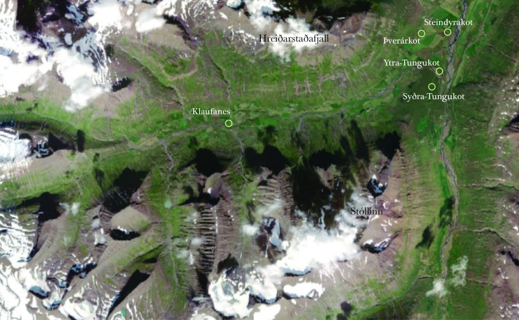
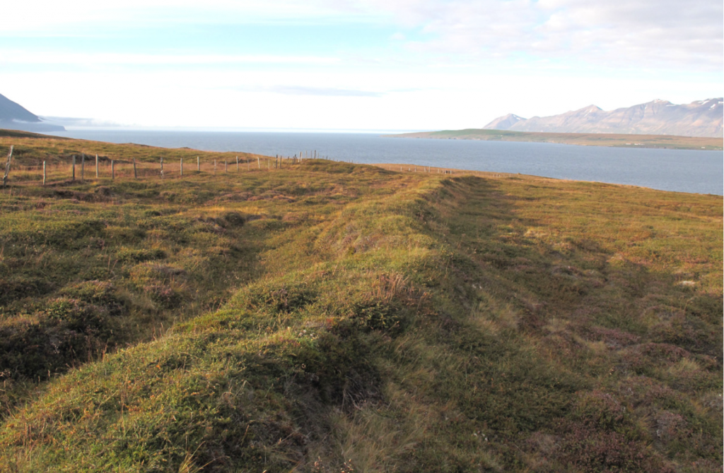
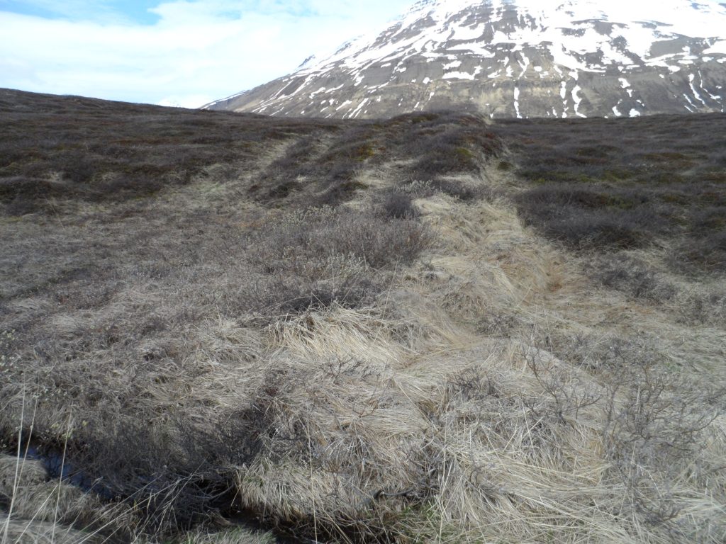
A team of five researchers was active during the summer 2020. Elín Ósk Hreiðarsdóttir, Lilja Björk Pálsdóttir, Lilja Laufey Davíðsdóttir, all archaeologists, and historians Árni Daníel Júlíusson and Axel Kristjánsson did research on the age of four suspected medieval farms and one confirmed, that was revisited by archaeologist for the first time since 1940. That was Klaufanes, also the subject of research with the earth radar during May 2019. The other four medieval ruins investigated were Steindyrakot in Steindyr, Þverárkot in Þverá and Ytra- and Syðra-Tungukot in Tungufell.
The results of the research are that all four of the last mentioned suspected medieval farms were indeed deserted medieval farms. Test trenches were dug into three suspected medieval earth walls connected with these farms, Steindyrakot, Þverárkot and Ytra-Tungukot, and in all of them tephra was found that showed that most likely these farms were inhabited during the period ca. 1100 to 1400. Coring in Syðra-Tungukot showed very similar results.
The results from Klaufanes were less clear. The ruin of an old farmhouse at the site was dug out by Kristján Eldjárn, Hjalti Haraldsson and Baldvin Jóhannesson in September 1940. The ruin was located during the 2019 earth radar investigation mentioned above. However, coring during the 2020 season in Klaufanes showed, along with new information from air photography from 1954 made available to the project by Landmælingar Íslands, that the ruin was slightly further to the north than originally thought. Also the results from the coring in Klaufanes showed that possibly very little was left of the old ruin structure because of farm improvements, plowing etc. Clear results will only be available with test trenches.
The fact that four farms from the middle ages were found in Svarfaðardalur in addition to Klaufanes, which Kristján Eldjárn believed was a 10th century structure, is very interesting. The four farms seem to have been ordinary small farms inhabited for a long time, several hundred years, with family farming with cows and sheep. The fact that no contemporary evidence about these farms is available makes it very necessary to do more research on them.
The present team of archaeologist, paleoecologists and historians has done extensive research in the Two Valley area before. Around the turn of the millennium and until 2008, the entire area was surveyed for archaeological remains for the first time by a team from the Fornleifastofnun Íslands (FSÍ), among them Elín Ósk Hreiðarsdóttir, Stefán Ólafsson, Orri Vésteinsson, who are all connected with the present research, and many others. The survey showed a large number of many kinds of remains. Among the most interesting for the present research is the many deserted farms. Also the many deserted shielings or summer farms that in the old times were used for butter and skyr production from cow and sheep milk. A huge system of earth walls designed to control land use was also found. A separate projects was organized and in 2010 Elín Ósk Hreiðarsdóttir investigated the age of the earth wall system. It was dated to have been established in around 950, and parts of it were still in use in the 14th century. After that it declined and fell out of use.
In 2015, the National Museum of Iceland decided to award the Dr. Kristján Eldjárn research fellowship to Árni Daníel Júlíusson. It was renewed the year after. The goal of the research program was to write a history of Svarfaðardalur 870 to 1500 using all available sources, the plentiful written material starting after 1100, some of which gave information on the period before that time, and the archaeological surveys and archaeological research already available, which sheds light on the whole period. The result was a synthesis of sources creating an integrated account of the history of the valley, published as a monograph to commemorate the 100 year anniversary of Dr. Kristján Eldjárn´s birth, 6 December 2016. The monograph is called Miðaldir í skuggsjá Svarfaðardals, which can be translated roughly as „The Middle Ages in the Mirror of Svarfaðardalur“. Kristján was in his time the foremost archaeologist in Iceland. He was born and bred in Svarfaðardalur. In 1947 he became head of the National Museum of Iceland. Kristján was elected the president of Iceland in 1968, a post which he held unchallenged until 1980, when he decided that 12 years as a president of Iceland was enough for him.
Returning to the Two Valley research, during he second year in the research position named after the late president at the National Museum, 2016-2017, Hörgárdalur was added to the mix using the same methods as in Svarfaðardalur. An english text was then produced discussing the findings of the research in both Svarfaðardalur and Hörgárdalur. This text, called „A Tale of Two Valleys“, is now under preparation for publication.
Click here to go the weblog for „Miðaldir í skuggsjá Svarfaðardals“.
In the summer of 2018 two archaeologists, Elín Ósk Hreiðarsdóttir and Lilja Björk Pálsdóttir went with two students and Árni Daníel Júlíusson to investigate some sites in Svarfaðardalur. Three sites were targetet, a part of Sveitarlangur in the inner part of Svarfaðardalur, on the farm Þorsteinsstaðir, the Merkjabýli farm near Dalvík (also sometimes called Elínarstaðir after the discoverer of this farm, Elín Ósk Hreiðarsdóttir), and the old sub-tenancy Kot in Skíðadalur. Eventually only the two sites first mentioned were investigated. The results from a trench at Þorsteinsstaðir showed that Sveitarlangur was of the same age as this earth wall elsewhere in Svarfaðardalur. There had been doubt as to what age the settlement in the inner/upper part of Svarfaðardalur (Fram-Svarfaðardalur) was. It showed some characteristics not seen in the lower part, many small farms, few churches and no pre-christian burials, so the hypothesis was that it was settled later than the lower valley. The test trench in Sveitarlangur above Þorsteinsstaðir showed that this was not so, that this part of the valley had been settled and its farmland organised at the same time as the farmland in the lower valley, and a very important piece of evidence was thus obtained.
In May 2019 a team of researchers went to Svarfaðardalur from Reykjavík to do an earth scan with an earth radar („jarðsjá“) at Klaufanes. The team, headed by archaeologist Ómar Valur Jónasson located what seemed to be the remains of an old skáli, which had been dug up by Kristján Eldjárn and his team in 1940. The results seemed promising at the time, but further research showed somewhat different results, as discussed below.
A team of five researchers was active during the summer 2020. Elín Ósk Hreiðarsdóttir, Lilja Björk Pálsdóttir, Lilja Laufey Davíðsdóttir, all archaeologists, and historians Árni Daníel Júlíusson and Axel Kristjánsson did research on the age of four suspected medieval farms and one confirmed, that was revisited by archaeologist for the first time since 1940. That was Klaufanes, also the subject of research with the earth radar during May 2019. The other four medieval ruins investigated were Steindyrakot in Steindyr, Þverárkot in Þverá and Ytra- and Syðra-Tungukot in Tungufell.
The results of the research are that all four of the last mentioned suspected medieval farms were indeed deserted medieval farms. Test trenches were dug into three suspected medieval earth walls connected with these farms, Steindyrakot, Þverárkot and Ytra-Tungukot, and in all of them tephra was found that showed that most likely these farms were inhabited during the period ca. 1100 to 1400. Coring in Syðra-Tungukot showed very similar results.
The results from Klaufanes were less clear. The ruin of an old farmhouse at the site was dug out by Kristján Eldjárn, Hjalti Haraldsson and Baldvin Jóhannesson in September 1940. The ruin was located during the 2019 earth radar investigation mentioned above. However, coring during the 2020 season in Klaufanes showed, along with new information from air photography from 1954 made available to the project by Landmælingar Íslands, that the ruin was slightly further to the north than originally thought. Also the results from the coring in Klaufanes showed that possibly very little was left of the old ruin structure because of farm improvements, plowing etc. Clear results will only be available with test trenches.
The fact that four farms from the middle ages were found in Svarfaðardalur in addition to Klaufanes, which Kristján Eldjárn believed was a 10th century structure, is very interesting. The four farms seem to have been ordinary small farms inhabited for a long time, several hundred years, with family farming with cows and sheep. The fact that no contemporary evidence about these farms is available makes it very necessary to do more research on them.